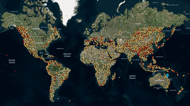
There are a total of about 530,000 potentially feasible pumped hydro energy storage sites worldwide, with a total storage potential of about 22 million GWh. These astonishing numbers come from a report recently released by Professor Andrew Blakers and other researchers with Australian National University’s RE100 Group.
Pumped hydro already constitutes 97% of electricity storage worldwide because of its low cost, ANU says, and the proportion of wind and solar photovoltaics in the electrical grid is extending considerably. This means “additional long-distance high voltage transmission, demand management and local storage is required for stability.”
ANU researchers identified the potential sites and their potential using geographic information system (GIS) analysis.
The massive storage potential of about 22 million GWh “is about one hundred times greater than required to support a 100% global renewable electricity system,” ANU says. An approximate guide to storage requirements for 100% renewable electricity, based on analysis for Australia, is 1 GW of power per million people with 20 hours of storage, which amounts to 20 GWh per million people.
The identified sites are outside national parks and are mostly closed-loop (not river-based). Each identified site comprises an upper and lower reservoir pair plus a hypothetical tunnel route between the reservoirs, and includes data such as latitude, longitude, altitude, head, slope, water volume, water area, rock volume, dam wall length, water/rock ratio, energy storage potential and approximate relative cost (categories A-E). Brownfield sites (existing reservoirs, old mining sites) will be included in a future analysis.
Click here to access the AREMI websitezbsczzexsfxsvxswaawew, which offers detailed global visualization (click Add Data/Renewable Energy/Hydro/Storage). AREMI is supported by the Australian Renewable Energy Agency and Data61.
In this comprehensive global atlas of pumped hydro energy storage sites, users can browse to any part of the world and zoom in to obtain detailed synthetic images. Users can explore thousands of sites in specific locales, sorted by size and capital cost. Clicking on a reservoir or tunnel route produces pop-ups containing detailed information.
Note: None of the PHES sites discussed in this study have been the subject of geological, hydrological, environmental, heritage and other studies, and it is not known whether any particular site would be suitable. The commercial feasibility of developing these sites is unknown. There has been no investigation of land tenure apart from exclusion of some environmental areas and urban areas, and no discussions with land owners and managers.


